Indian Canyons Photo Tour
Indian Canyons Photo Tour
DAY 1: Mon. 28.9.15 : Las Vegas to Grand Canyon
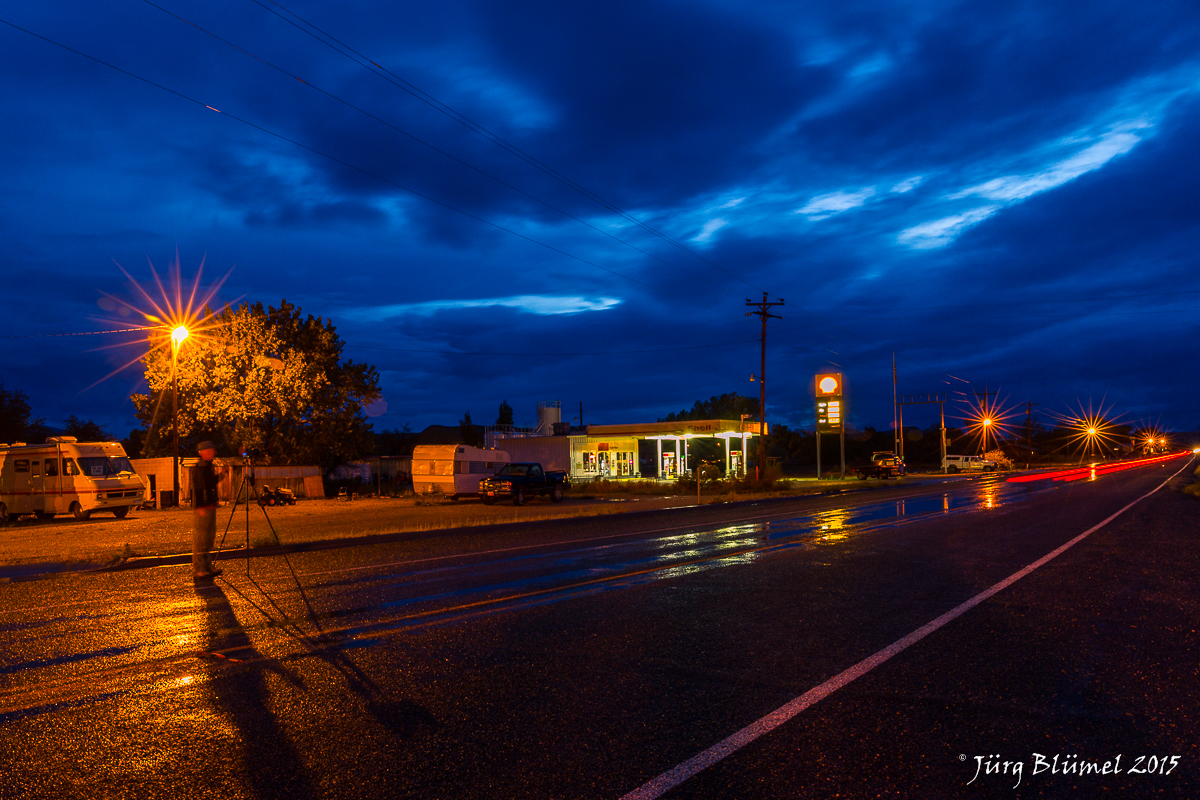
At 08:00 sharp we leave Las Vegas direction Grand Canyon. We stop for a coffee and to fill up our water supplies after an hour. Another hours drive gets us to Seligman, a short detour on the historic route 66. It is totally touristy but sooooo cool ! There are so many motives, so many colours, I could have stayed for ages. Old cars, route 66 signs, shops, bars and restaurants, all old style, partly even more than a bit rusty, but great to photograph. We take a lot of shots, 66 is our year of birth which makes it extra special. From there another hour to Williams, also a route 66 town but not quite as good as Seligman, we have lunch at Cruisers Cafe 66, hamburgers what else. The inside is decorated just I would expect an American diner to look like.

The very cool town of Seligman on Route 66

The perfect American Diner in Williams
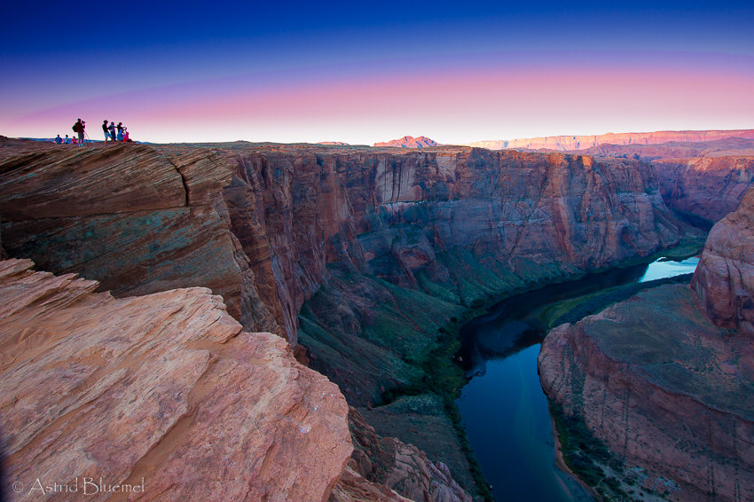
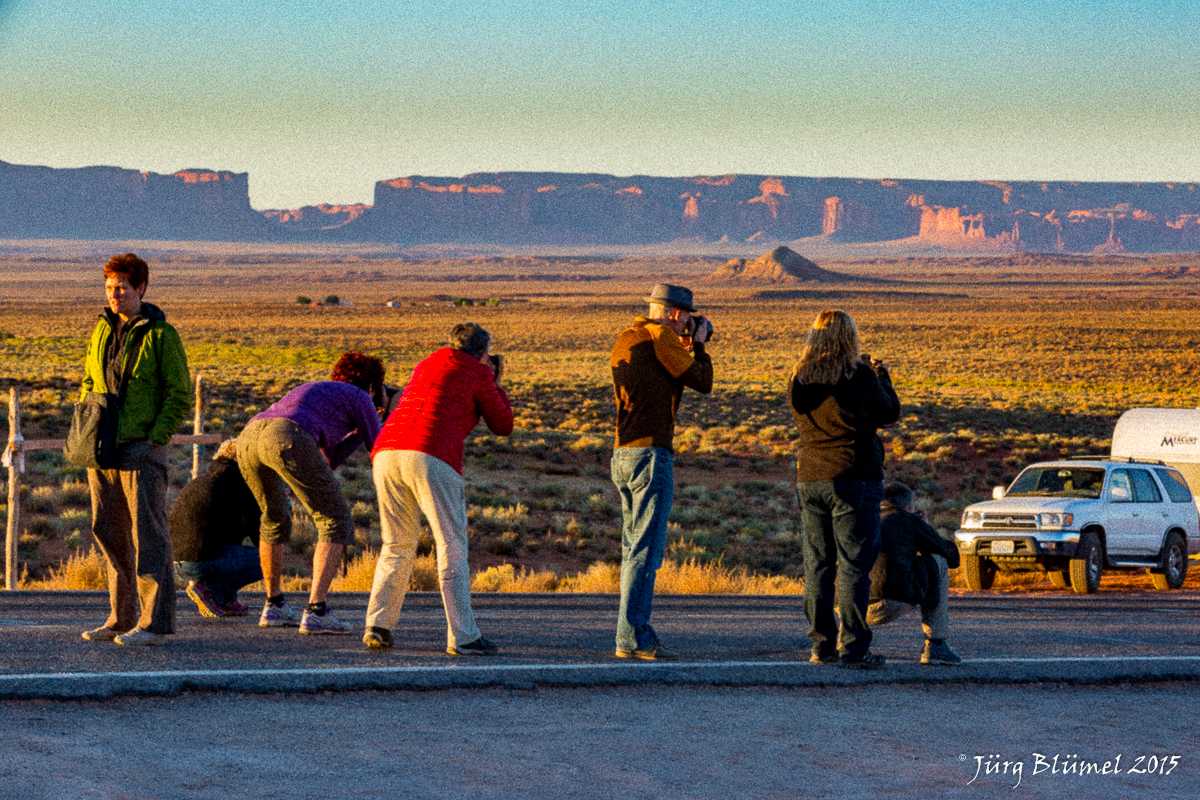
Spare time till 14:00 to walk about town and try to get some more good shots, but honest it’s not half as good as Seligman. By about 15:30 we get to the Grand Canyon, the room is not ready yet so we go straight for the first viewpoint, stopping along the way at a good roadside view to ” get in the mood” . The Moran viewpoint is good at sunset and we stay quite a while, the second stop is at Grand View, which has a beautiful dead tree which adds a little to the photos, not just rocks … Incredible, the canyon is 10 miles wide and 1350m deep, it is so very very big, it really is hard to do it justice in one photo !

Juerg is getting a little too close to the edge
For dinner we have a salad at the self service restaurant at our Maswik Lodge.
DAY 2: Tue. 29.9.15 : Grand Canyon to Tuba City
The 8:00 am departure yesterday was a luxury, today the alarm goes off at 05:00, we are all ready to leave for first light in the canyon at 05:15. We are getting good and are already amazingly fast at getting up and getting dressed ! This time we go to Mather Point, it is beautiful. For the first 5 min we are alone and can find us a good spot, then the busloads of tourists are dropped off for a rim sunrise. Jürg shoots in the “into the sun” direction, I shoot away from the sun so we can cover both angles. As the light comes we are once again amazed at the scenery below and in front of us, this is great even without a camera ! At around 07:00 we head back to the Maswik Lodge for breakfast, we have some spare time and at 10:00 we leave for Cameron, and Tuba City. We do one more stop at the Grand Canyon, this time at Desert View viewpoint. This is in my opinion the most beautiful of all, simply breath taking, must be great at sunset too, but was too far from our lodge fora sunset shoot. It is still beautiful in morning light. There is an old tower at the edge, makes for some good shots. It is so awesome here that I spend the last 15 min before we head on just sitting on a rock and enjoying the view.

At 11:30 we move on, a short stop and hike at the Marble Canyon. At its bottom is the Little Colorado River, well not now, it is totally dry and at midday the light is much too harsh to take any good pictures. So we hike back to the car. Even for us Death Valley heat trained it is getting to be very hot once again. The Trading Post at Cameron is just a gigantic souvenir shop, plus lodge and restaurant. I have a Navajo Taco for lunch, some Indian bread topped with everything that usually is in a taco, plus minced meat and beans, tastes good but I am glad I shared the portion with Anasztazia, would never have been able to eat it by myself. From here it is only about 15 miles to the lodge in Tuba City, the Quality Inn. This really isn’t a very nice town, everything spread out, far apart, just fast food chain restaurants and the houses don’t look very nice either. The lodge is okay, the room clean and big enough, the bed good. All the motels we stayed at so far are much alike, big room and bath, 2 queen beds, tv, carpet on the floor, air conditioning humming away, nothing spectacular so I’ve stopped taking photos of the room, one will do for all of them, they all look alike.

At 16:30 we meet our native Indian model Alyssa who normally is a school psychologist, and go to the Coalminers Canyon. First a few portrait shots of her in front of the lodge, she wears a pink dress and a lot of the blue and silver jewellery, pretty face and good profile, on the photos she looks even better. We drive about 10 miles from town and turn left on an inconspicuous little dirt road. A great little canyon in red and white, with a few greyish rocks to the left hand side. We place her on a ridge, I love this part ! Ask her to turn, lift her arm and point, blend out the sun, sit, turn, look down and more. She is great very patient and sits very still so we ‘re still okay at slower shutter speeds. As the sun sets there is a lovely sunset sky so I ask Christian if we can put her on the ridge and photograph her silhouette. He then comes with the flash and lights her up as we shoot so you get the sunset and her in full colour, it’s my favourite photo of this tour so far, and it is only day 2, just pray it is focussed….. !

Coalminers Canyon & our model Alyssa
We are only back at the lodge by 20:00, actually 19:00 but we have to turn the clock one hour back, only the Indian Reservation has summer time, the rest of Arizona doesn’t, which is a little confusing.
DAY 3: Wed. 30.9.15 : Tuba City to Page
We can sleep late today… leave at 8:00 for Page, only about 60 miles. We drive north on the Hwy 89, turn right on the 20 after about 10 miles. In Page we do a short stop to get water, then on to the Antelope Canyon ! I really look forward to this part ! We get a private tour at 10:20 so we sit and wait for 1hr 20, because the Indians normally do have summer time, but in Page because of all the tourists they stick to Page time ( which is Arizona = no summer time) who cares, we get photo tips and there is time to write.

Patiently waiting till we can go down
Our guide in the canyon is a young girl called Quintana, or just Tana for short, who is absolutely sensational, she blocks of people, gets us in good spots, throws sand so we can see the sunbeams better and really cares about the place. She said she only does photography tours, doesn’t like the big tour groups, they just rush through and don’t really appreciate it’s beauty. We walk a short bit and go into the canyon at the “exit”. It is just a narrow slot, which at a lot of spots is just one medium sized person wide. We keep having to move aside to let busloads of Chinese tourists pass, the poor guys which guide these groups…they are like cowboys, driving a herd of stupid cattle ahead of them, keep going, move on now, no more pics, and the stupid Chinese don’t speak a word of English and are clearly the least favourite persons in the canyon. Tagging along with us is another photo group (you get 2 hrs instead of 1 and a good guide), with them there’s one Chinese guy in pink shirt, a typical Chinese who behaves as if he owns the canyon, bosses everyone around but is himself the biggest nuisance, is ultimately slow in getting his settings and composition, and in doing so messes up every ones shot, added to that he always stands or walks in to our photos.

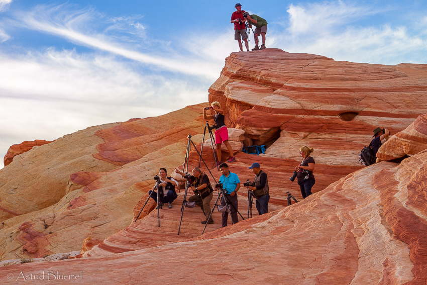
Antelope Canyon Photographers
We call him PINKY, and every time we see a Chinese with a pink shirt we say : oh help, Pinky is following us, or with any bothersome Chinese we say : oh here’s another Pinky. The guides call these people the selfie nation….But it was sensational, and except for the overload of Chinese bus tourists it was an incredible experience. There are new motives, shapes, curves around every corner. The walls glow in a dark reddish brown and sometimes beams of sunlight come down to the ground. Tana throws dust in the beam so we can see it better, over and over again till everyone has a good picture. The 2 hours pass by much to quickly and we have to make our way back out, boy this was an amazing experience. If you are serious about photography spend a little more and do book a photo tour !

leaving the slot canyon
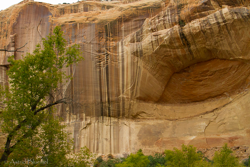
We plan to have lunch at the Thai restaurant in Page but is closed for 3 days so we go to the Mexican restaurant. It is so overly exotic, bright coloured and touristy that is actually quite cute. The food is good. After that we check in to the Super 8 Motel on the outskirts of Page. We have time till 17:00 after that, so download the photos and relax. Then we leave for the Hoodoos, about 20 miles north of town after crossing the bridge there is a small sign on the right hand side. You can’t really miss it because there are beautifully coloured red and white rocks and towers and ridges all around us just driving on the highway. We hike for about 20 min till we get to the main motive, a big pile of red rocks and two, three hoodoos in front of a white cliff face, another good site with mainly white hoodoos is on the left as you approach, just “round the corner”. After sunset we get set up and wait for the stars to come out, moonrise is at 21:00 or so so we have a little time. We get beautiful shots of the milky way, this is like the African skies, there are so many stars it is unbelievable how the light pollution we have back home makes this beautiful scenery fade out. I would have loved to camp out here, just lie on your back and watch the sky all night ! We are back so late we scratch dinner, have a cold beer and then off to bed.

Hoodoos at sunset
DAY 4: Thu. 1.10.15 : Page to Mexican Hat
We leave at 06:00 for sunrise at the Horseshoe Bend, or as the Chinese lady yesterday said ” the Horsebend shoe”. About 2-3 miles out of town in direction Flagstaff there is a parking lot, doesn’t look spectacular, there is only one car there. We hike up a short sandy hill, as we are over the top a dark shape ahead, like a horseshoe, can already be seen, we hike downhill from here to the very edge, I am so brave !!!!!
Looking out over the Horseshoe Bend
We really stand on the very edge and with a very wide angle lens you get the whole curve of the river in, the bend is truly like a horseshoe, in its middle a big rocky outcrop. The rocks are red and the river shimmers in a lovely blue and green at the bottom, wow, again we are at an incredibly beautiful place. Getting there is similar to Antelope Canyon, this one is also real close to the highway, but till the moment you right there you think there’s nothing to be seen. Imagine the first guy to walk over that hill and see this ! Good for us there are not so many people here, I honestly am not so happy with this edge, from here it goes straight down for I don’t know how many hundreds of metres. As long as I just look through the viewfinder I am okay. We put our backpacks behind us, creating some sort of safety barrier so no ignorant Chinese can come up from behind us to also take a picture here, at exactly the spot where we are standing. They have this terrible habit and always go where the people with tripods are, they really have no imagination so the go where everyone else goes, do what all others do, and if you walk around with a tripod you are their favourite prey. Luckily it is very quiet this morning, only a handful of people and they spread out. But still I am quite happy to step back a little as we are done. Let’s go for breakfast, but first please let’s go get a coffee at Starbucks.
At 11:00 we move on via Hwy 98 then Hwy 160 east, to Kayenta for lunch, but the one place is closed, the other overly full, so we move on to Mexican Hat. From Kayenta we are on the Hwy 163 which takes us through Monument Valley. This is said to be the best part of Monument Valley and it really is spectacular. It is as flat as a pancake, well almost, and jutted across the plains are these big red rock formations. This is truly Marlboro country, you’d expect a cowboy to come riding across the plains, or almost expect 20 or more Indians on the flat topped rocks looking down at you. We stop a little way past the rock formations, now, as we look back, we see the classical Monument Valley view, a long straight road leading up to the rocks. Too bad the sun directly in front of us, but Christian promises to get us back at this spot tomorrow morning. Lunch at the San Juan Inn is ok, the usual junk food on the menu but it tastes good.

This rock got the town its name
At 17:00 we leave for the Valley of the Gods. Drive north on Hwy 163 after a few miles north we turn right and stop at the rock formation which gives the town its name. Looks like a big fat guy with a sombrero. The turn off to the Valley of the Gods on Hwy 261 is not much further on the left. And after a few miles we turn right and it’s dirt road from here. The scenery is again impressive, looks somewhat like Monument Valley.

Valley of the Gods
It is kind of hard to photograph, we do set up at a beautiful spot, but nobody is really satisfied with the results, so what, the scenery is amazing once again, we’ll just enjoy the sunset and the everlasting wonderful weather. A half hour drive and we are back at the Inn where we all go for dinner, after which Jürg, Frank and I drink a bottle of wine on the deck during which I fall asleep, am getting a little tired.
DAY 5 : Fri. 2.10.15 : Around Mexican Hat
They are being really nice with us, we only have to leave at 06:30 ! The Goosenecks State Park is just a few miles north on Hwy 163, then turn left on Hwy 26, another mile and left again, follow road for 3 miles to a parking lot right at the rim. This is like the Horseshoe Bend, except here the river winds and winds, it’s like 3 bends put together. Jürg gets in position to do a pano, I move about to take photos from as many different angles as possible. Get a few nice ones, again with a, this time green instead of yellow bush, and one with a lot of rocks in the foreground. My favourite time is just shortly before the sun rises, the colours are just the best at this time especially down in the canyon.

Goosenecks in the San Juan River
We continue on to the Valley of the Gods, but first we go up on a steep and narrow dirt road, the Moki Dugway, to Muley point. Here we get a good view of this road winding up the hill, nice morning light on it. We then continue on the 17 mile long, partly very bumpy dirt road with the same sensational views as yesterday but now in morning light. Two more photo stops then we move on because everybody is hungry and we desperately need a coffee too. The road leads us back on Hwy 163, turn left to Bluff where we have breakfast in the Comb Ridge Bistro. Jürg has pancakes, which are sensational, so is the cappucino. I have the quiche, which is more like an omelette but tastes good too. The pumpkin muffins aren’t bad either ! We drive a little further on to the Cow Canyon Trading Post where there are some old cars, Dodge and so, rusting away in some ones backyard, good photo motives ! Then it’s back to the Inn.
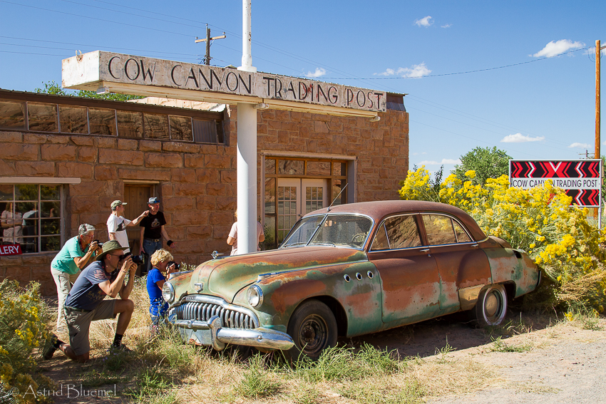
Now what can be so interesting about this car ?
Since we had such a late and big breakfast we all decide to skip lunch and meet at 14:00 for portrait photography. That was fun, and we all looked pretty good on the pics, look sideways, don’t smile to much, they even brought a big fold-away reflector to add sunlight from the side as we were standing in the shade. That is much better than in the sun where you get lots of shadows and people with closed eyes ! At 15:45 we meet again for the trip to Monument Valley where we have a tour with a Navajo guide. We arrive a bit early at the Gouldings Resort because the road works are not there anymore, our lucky day, the tour starts 15 min earlier ! Our guide is an Indian lady called Colette, as I ask if she has a Indian name as in the movies, like “lady with black hair blowing in wind”, she laughs and says no one has those… First we stop at the visitor centre, from there you have a wonderful view over the valley, the monumental rocks in the plains in front of us. From there to John Ford point, a great view as it is, but then an Indian on a horse rides out on the ledge and looks out over the land in front of him. Okay it is a fake touristy thing, but boy it looks good !
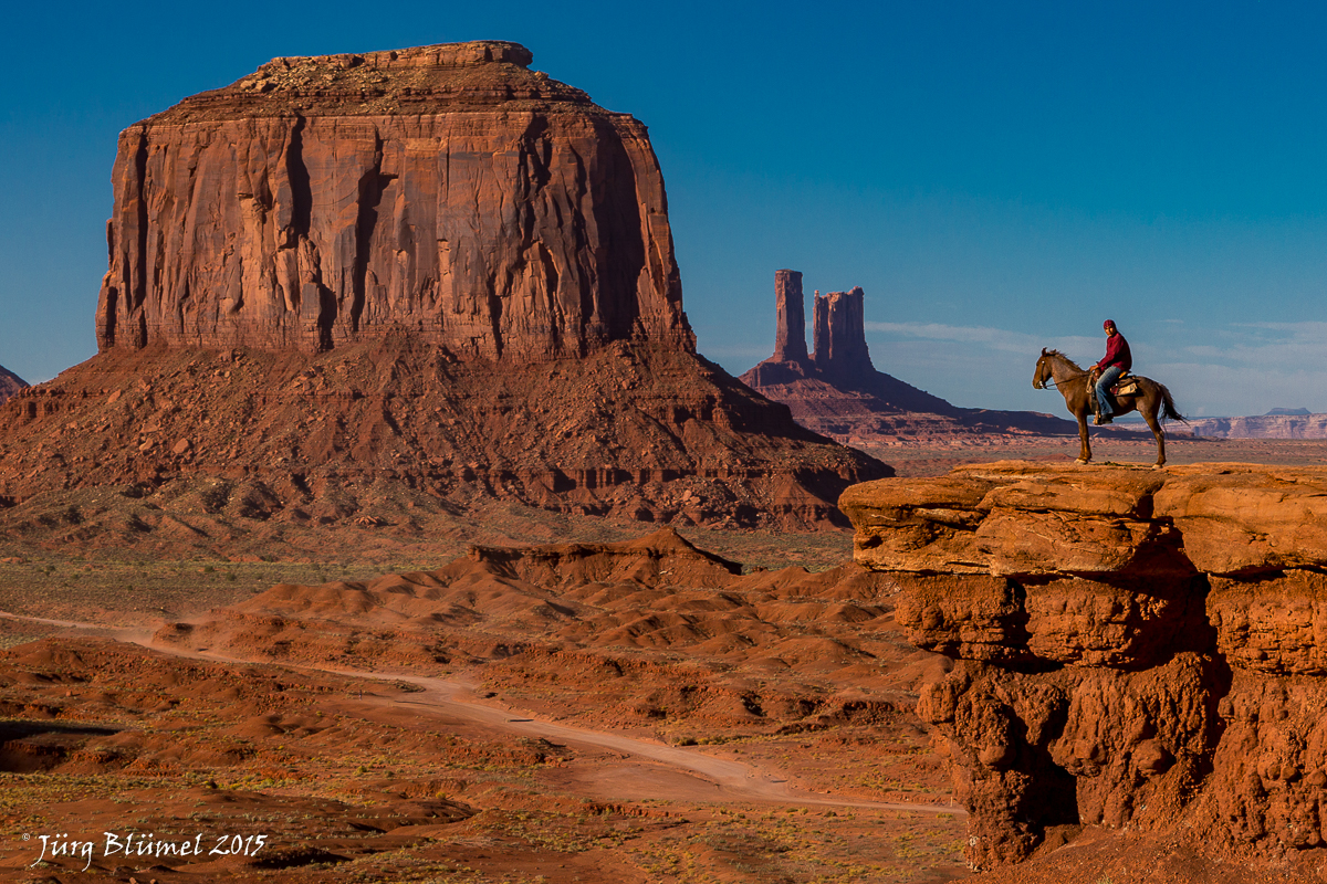
Winnetou
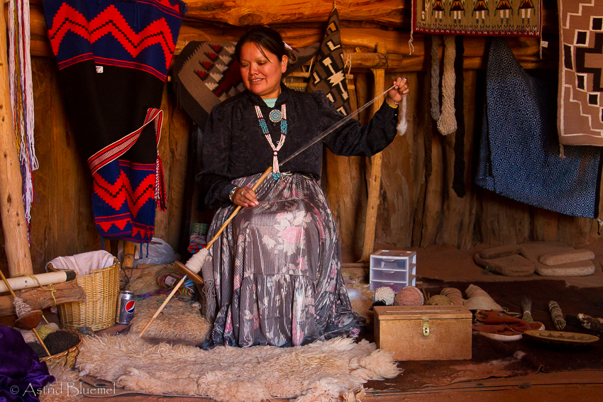
Weaverin
From there to an Indian clay hut, a kiva, a woman and girl are in there and are weaving, again very posed, but she is a cousin or so of our Colette and talking to Colette a little less stiff and great photo opportunity again. Jürg can do the landscape I’ll stay in here till we leave. Then to the totem pole. Now I thought it would be a wooden totem like the ones we saw in Canada. No way, of course here it is a red rocky one, very thin, very high, looks great with the cumulus clouds behind it ! We decide to stay for the sunset shot, but a big rock formations is blocking the sun and throwing shadows, and it will take much too long to get from here to the park exit (we have to leave by 19:30), so we move to our first spot at the visitor centre. Get some nice shots and Jürg and Christian got one with a thunderstorm flash in it.

Monument Valley at sunset
DAY 6 : Sat. 3.10.15 : Mexican Hat to Moab
Not too bad today, we only have to leave at 06:30, that’s again almost like sleeping late. It is only a 10 min drive south on Hwy 191 to reach the viewpoint. There is already one group of photographers standing on a ridge a little further down and one bothersome guy in a blue shirt which keeps standing in the middle of the road, and so in the middle of our picture, but we manage to get some nice sunrise shots.
We shoot, Regula watches and makes sure we don’t get run over…
Back to Mexican Hat to pack and shortly after we leave to have breakfast in Bluff once again. This time everybody has the bluecorn pancakes, they are really good. To tell the truth, the best breakfast on tour so far and it stays that way, they are not beaten till the end of the trip, sensational, must try to make them at home ! We do a short stop at the outdoor museum which shows some old pioneer time cabins and covered wagons, then move on to the town of Blanding, about an hours drive on the Hwy 191 north.
Here we go the Edge of the Cedars State Park, there is a museum showing Indian artefacts. One house we can enter, they are called Kiva. Makes for some nice shots with the wooden ladder coming down and a few rays of light. Christian decides to throw some dust as in the Antelope Canyon, we see the rays even better now. Inside the main building they have some rock paintings which remind me a lot of those in Namibia. It is nice to photograph something else than red rocks for a change.
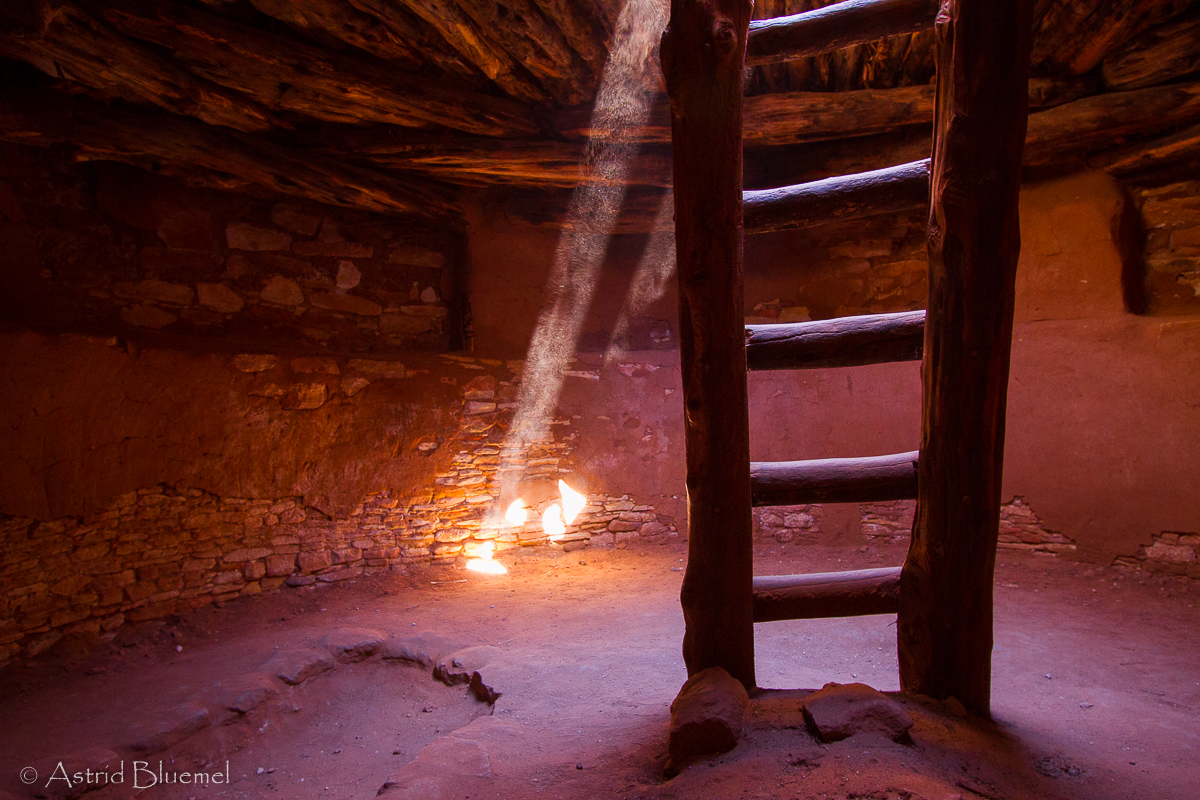
Indian Kiva at Edge of the Cedars S.P.
Another hour gets us to Moab. Shortly before we get there, there is a huge arch just by the the highway called Wilson Arch. we climb up the rather steep hill to the foot of the portal, it is really, really big now that we are standing under it. After waiting a while we even get some shots without people, but the people in the picture are quite good too, so you can see the dimensions ! Our motel here is the Hampton Inn, one of the more luxurious ones on this trip. Moab is the centre of a lot of tours and trips so it is usually booked out well in advance. We skip lunch after the big breakfast, it is already 14:00 anyway.

Wilson Arch near Moab
At 16:00 we leave for the Canyonlands National Park, it is split into three parks, the part we visit is called Island in the Sky. We stop at Shafer Point Overlook. Wow ! What a view ! Of course Jürg and Christian stand frightfully close to a steep drop once again, but they make for good photo motives. There is a road leading down to the canyon floor, the Shafer Trail, the road looks a little like the Moki Dugway we saw in the Valley of the Gods. From there to the next overview, this one is Green River Overlook. It looks over the congruence of the Colorado and Green River. There are lots of winding gorges down at the valley floor, the whole scene is backlit and some dead trees at the edge make the whole thing look rather doomy, a bit like “Mordor” in Lord of the Rings.

Green River Outlook in Island in the Sky
We stay here till sunset then head back to Moab to have dinner at a Thai restaurant called Singha. We have to wait about an hour for a free table, which time we spend in the shops and the Tom Till Gallery ( for inspiration), whilst Regula and Christian stand in line, but it was definitely worth the wait, best food so far, except for the steak at our hotel in Vegas that is, but that one doesn’t count. After downloading all photos and selecting and charging and cleaning it is 23:30, better get to bed bcause we have to leave at 05:30 tomorrow !
DAY 7 : Sun. 4.10.15 : around Moab
It is rather hard getting up at 05:15 but we don’t want to be sissies, besides, I saw a photo of the Dead Horse Outlook and it looked real good. About 12 miles north of Moab we turn away from the Hwy 191 north onto the 313, another 12-13 miles or so and we turn left to the outlook. Down below us a river flows through the eroded valley, looks super as far as we can see in this little bit of light. It gets better and better, a few other photographers and tourists show up, honest my favourite time is 5-10min before sunrise, that’s when you get the best colours and the rocks really glow.

Dead Horse Point in Dead Horse S.P.
Back in town by 08:00 and straight to Starbucks, we are in desperate need of a coffee. With our coffees we go back to our hotel for breakfast, which is rather good here, there even is a waffle machine like we had in Norway, Jürg even goes for a second helping, that’s how good they are. The usual procedure after that, download photos, write the story, post some on facebook. At 10:30 we skyped with Silke back home, poor her, she is real miserable not being able to come along. After that we go shopping, buy some shirts and I buy myself an Indian silver and turkis bracelet, U$ 400,-, shit it is expensive, but it’s stunning. At 13:00 we meet in the pizzeria called Jay’s pasta, the pizza is very good, it will have to last us a while because we will be back very late from the Delicate Arch, will walk down after sunset( 19:00) for about an hour then plan do stars again before we drive back to town. No dinner planned for tonight.
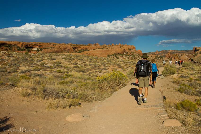
At 15:00 we leave for Arches N.P. Now this is one of my favourite parks, what great scenery ! The entrance is about 5 miles north of Moab on Hwy 191 north, a few miles into the park the first highlight, the Balancing Rock, a big chunk of rock precariously balancing on a bigger piece, wonder how long till that one comes down. We turn left at the parking lot and a few hundred metres up that road is a pick nick spot where we park. From the rocks up here we get a nice view of it with the mountains in the background. It is partly overcast so we wait for the sun to come out. When she does the rock really glows. We continue into the park and shortly after the rock we turn right to the windows section, which is really cool too. Next stop at the Garden of Eden viewpoint, which is okay but to me not very spectacular, then on to the windows. We park at the trailhead and do the short hike, there are two windows beside each other a third one a little more to the right, we climb a little, go through the Turret Arch and when you look back from here you get all three windows in one picture, the Turret Arch plus North and South Window. Another one we just drive by, the Double Arch.

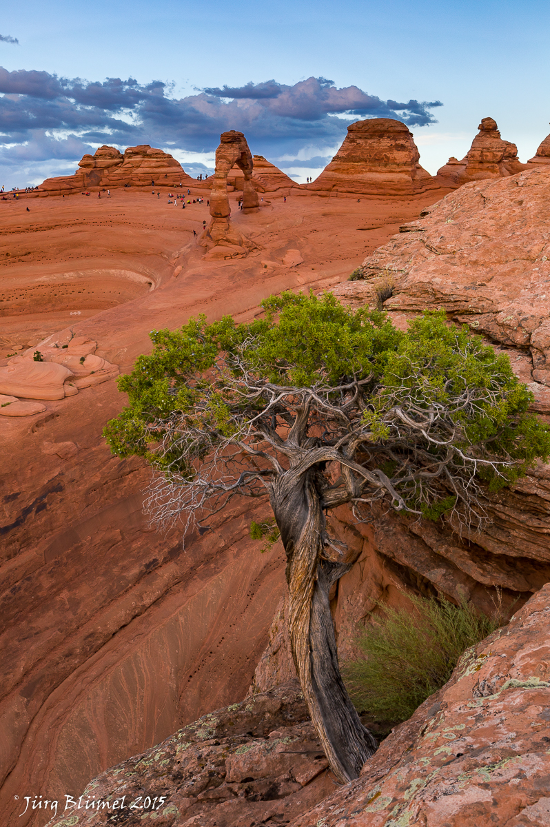
Back on the main road we continue north to the Delicate Arch, this is the one we will stay at till sunset. Now they tried to scare us by telling how steep and strenuous, long and slippery this trail was. Can’t be too bad, 3 miles with about 150 m elevation gain. Back home that would be a medium hike, here they say 2 hours, we do it in far less ! It is at times a little steep and good for us, it isn’t too hot, but even our oldy Yvonne, who is 70, gets up there without much problems. Once we pass the cliff at the end of a rock face you suddenly get full view of the arch, it makes everyone stop in their tracks, amazing ! At it’s foot is a natural amphi theatre, washed out by years of erosion, the arch is huge, people standing below it look like dwarfs.
At the start of our hike, headed for the arches way in the back

The Delicate Arch as you first see it
The whole top rim of the amphi theatre, which goes down quite steeply, is filled with tourists, mostly Chinese, ( shit, not again…) a lot of tripods and expensive equipment and even more noise. I am not so sure about the photographical knowledge of all these people…. As Greg said, “the amateur worries about the equipment”. We are more worried about the big black clouds covering most of the horizon, here goes our sunset and glow ! We all scramble around on the rocks trying to find a good angle. Tons of possibilities but every good shot is ruined by Chinese, posing in the strangest postures you can imagine, under or right beside the arch.

Trying a different angle, again no chance to get it without people
Jürg and Christian scramble down to the bottom and up the cliffs opposite searching for new creative angles, which they definitely do find ! A sunset without light it is not so good, no matter where from. So shortly after sunset we hike down making good use of the last light so we have at least some light going down. About halfway we do have to put on our headlamps, it seems much longer going down than up ! Back at our motel we have a beer and snacks at the poolside with Frank. I really like the Arches National Park, there are so many different things to photograph !
Delicate Arch
DAY 8: Mon. 5.10.15 : Moab to Hanksville
No chance of sleeping late today, we are so used to getting up early that I am awake by 05:30 anyway. Time to download, write, and select favourite photos, there is always something to do. We only have to meet at 8:00 for breakfast, such luxury… This only because the weather forecast is very bad, cloudy and 70% chance of rain, which definitely comes true, it’s grey, dark and rainy as we get up at 07:30. Breakfast is okay here, after all have filled their stomachs we go shop for snacks and water plus we need a good coffee. The lady at the Starbucks looks so grumpy we decide to try another coffee shop. Not really a good idea, the coffee is good but there are so many people waiting and the one guy making the coffee so slow that we stand in line for half an hour. Back at the motel Christian does a sunset photoshop lesson, about putting your thumb in to prevent the sunflares, and putting in layers to cover up and change the colours and more, good ! We leave at 11:00, drive north on Hwy 191, then west on the 24. Because of the never ending rain and grey clouds we don’t really see much of the countryside we pass, it doesn’t look too interesting anyway, rather flat and empty. As we get closer to Hanksville the rock formations finally show up again, it is a little lighter on the horizon, we are hoping for some sunlight in the afternoon.

Gobelin Valley
As we arrive in Hanksville we turn right and go to Duke’s Slickrock Grill for lunch, I had a Texas Cyclone, a roasted bun with slow smoked beef stripes on it and it was delicious. The rain stops and as we drive back about 20 miles, on the 191 the sun even comes out. We reach the Gobelin Valley and are immediately surrounded by red rocks with green layers in them, extraordinary shaped rock formations all over the place. We stop at the “Sitting Ducks” three funnily shaped rocks in the middle of the open field and with some imagination they do look like ducks. Then on to the main attraction, the Gobelins. Once again we stand in awe at the rim of a rather wide and not very deep canyon. On the opposite side the top layer is green and this lights up in the rays of the sun which are now peeping through the clouds more and more. At the floor of the canyon there are dozens and dozens of rocks shaped like gobelins or mushrooms whatever you want to call it. The one problem is the rain, it is not raining anymore but now we know why they call this slickrock, shit, it is slippery as hell ! So we all slip and slide down the pathway and soon all are an inch taller from the mud sticking to the soles of our shoes. This place is once again so fotogenic, we soon split up and everybody finds a motive of their liking. The rain has made it slippery, but also formed nice patters where the water ran down the slopes and between the Gobelins. At the far left corner we find the best spot, the floor has large areas of white, black and green contrasting perfectly with the red rocks. The sun keeps coming out and we are soon so hot the sweaters and jackets come off. In the back the skies are a threatening black and grey, so we dare not stay too long and start heading back to the parking lot after an hour and a half.
Hanksville
As we get to Hanksville the rain starts again and adds to the gloomy scenery, our motel looks like one out of a Hitchcock horror movie, old, plain brown, one row of motel rooms, a gas station where nobody stops across the street, and all around us empty fields. The rooms are really okay though and we sit on the porch covered from the now heavily pouring rain, and chat and write, and have a laugh. At 19:00 we leave for dinner at the same place we were this afternoon, just as we are seated we decide we do want to do some photos in the blue hour in the rain so we race out again, leaving Regula, Yvonne and Tina to guard the table. Our motive is a gas station, lit by the light of the neon screens flashing advertisements and street lamps reflecting in the puddles. Half an hour later we are back. Dinner was good and by 21:30 we are back at our motel.
DAY 9 : Tue. 6.10.15 : Hanksville to Boulder
The morning shoot was disastrous. The original spot at an overlook could not be reached because of yesterdays rain. We left at 06:30, drove towards the red rocks, which weren’t very scenic after all, so we turned back to some other rocks which were just as bad. The sky was covered in big fat clouds and we had to use an app to find our where she was supposed to rise…. No subject, no light, I considered not even taking out the camera in such crappy circumstances. Christian said it was great, he got a great shot, okay he has to sell his trip and keep us happy. So we ended up photographing the road with a very light pink haze on the horizon. The only good thing was the discussion between Christian and me, he kept trying to praise the spot, whilst I put it down : just a crappy shoot, crappy road, waste of good megabites and so, it was hilarious and much better than the sunrise. We laughed more than we took photos. As it got light we drove back to town and did some photos at and old rusty Dodge parked at a deserted gas station, now that was cool ! So the morning wasn’t too bad after all. Breakfast was in Stan’s Steak Shak, a diner with chairs and tables bolted to the floor and an elderly lady guarding the breakfast selection as if it was something very special…it was very average.

Trying to make the best of it
At 09:00 we left for Boulder. The first part of the route was on Hwy 24 west passing through Capitol Reef N.P. At first there were black mountains with grey hills and ridges before them, then the beige and brown rocks with stripes in shades of red and pink, later the red rocks with the green layer in it. The scenery here is once again superb. We have seen quite a lot but are still amazed at what we see just driving along !

Capitol Reef N.P.
We do a short photo stop at the visitor centre and have a coffee break at Torrey where we then turn on to the Hwy 12, a very scenic drive going uphill till we reach about 10’000 ft. The aspen forests are yellow and green and make for some good photo motives even though the sky is a drabby grey. For lunch we stop at the Burr Trail Trading Post, the food in the Burr Trail Grill is very good, we’ll go back here tomorrow, especially since we haven’t tried the delicious looking pies ! As we drive along and start our descent there are canyons on both sides of the road, and I mean deep canyons and right beside the road, we are driving on a ledge with gaping drops on both sides. Now I know why the call it Staircase Escalante, it is like going down a staircase.

Hiking to the falls
passing colourful rock formations
At the bottom we park and hike to the lower Calf Creek Falls on a mostly even, sandy trail. We do some pics of the flowers and cactus we pass wondering how far we still have to go, it seems a never ending path. Christian tells us it is 1.2 miles, but as an hour passes and we are still no where near a fall we don’t really believe him anymore. At last, after more than 3 miles we reach the falls which are very scenic, so we run around trying to get it from its best angle. The water comes down curiously shaped and striped rock formations which are smoothed by years of passing water, some with green algea on them, adding green to the colour palette, a small sandy beach is in front. I do some lovely close up shots of the rocks with the flowing water.

Lower Calf Creek Falls
The hike back, which without photo stops takes only 1hr10min, is not too bad. We have a short break where everyone is eating something, and then move on to our next adress, shortly before we reach Boulder we turn off on a dirt road, after 6 miles we reach the Boulder Mountain Guest Ranch. A log cabin style house built in the middle of no where, horses in the fields around it, a little river flows past. We get a little cabin each, this is so remote and quiet, just perfect !

Our little cabin

The cozy lounge
We meet in the cosy lounge for beers before dinner, have to wait till 20:30 till the other big group is finished then it’s our turn for dinner. It was worth the wait ! After that we’re off to bed, all the getting up early is taking it’s toll on most of us and we don’t look so fresh and fit anymore… Today was a nice and different day, no red rocks ! First the morning shots on the road, then the old Dodge, followed by green and yellow fall colours of the aspen driving Hwy 12, again old cars at our lunch stop and the waterfall to end the day. And the best part was as I asked Christian to rate his super photo from this morning on a scale from 1 to 10. He said a 3, so I was right after all ! It was a bullshit shoot this morning and a waste of good pixels !
DAY 10 : Wed. 7.10.15 : around Boulder
We get up at 06:45, it is freezing cold in our cabin, I believe we had temperatures under freezing point this night. We don’t really want to get out of our warm bed but don’t want to miss out on something spectacular either, so we get up and dress real fast. We leave on foot at 07:00 to go photograph the small waterfall on the lodge grounds. Again a very muddy and slippery trail, we can start cleaning our shoes again when we get back…Another wasted sunrise, the fall is not there anymore, instead there is a beaver dam, which filled the river, it is not worth taking even one photo, so we immediately go back to the lodge for breakfast, truly enjoying being in the cosy and warm dining room, we are all rather cold and have wet feet. There were fruits and muffins, coffee and tea. At exactly 08:00 they bring the eggs and potatoes, two big plates full, one with scrambled eggs with herbs and mushrooms, the other with hash brown with onions and herbs. It was really good.

Burr Trail
After that we pack up and go, drive down the Burr Trail. A good tarred road lined with trees behind them are beige, grey and white rocks with the occasional tree growing out of a crack. The first stop is at the greyish white rocks to photograph one of these trees. Had we know all that was to come… we wouldn’t have wasted so much time there. At a viewpoint we see the road winding through a medium wide canyon of the, by now so well known, reddish coloured rocks. It got even better once we got to the canyon floor, the right wall was full of mostly round or oval holes of different sizes, as Tina fittingly said: like a Swiss cheese. There were some nice trees in front so we did rock photography and wandered further and further along the road till we found the perfect spot. The holes seemed to glow from the inside, this will be one of our very best pictures for sure. Shortly after that we found some white cliffs with red hoodoos in front, combined with the very blue sky also a good photo motive. It was about 23 miles to the viewpoint where the tarred road ends and turns into a dirt road as it descends. We turn around, no more time to go further at the pace we are moving at, we are stopping every 500m or so to take more photos. The view is spectacular once again and below us are multi coloured hills of sand, almost like the coloured earth in Mauritius.

Burr Trail
The drive back is interrupted once more as we stop at a slot canyon. It’s not really a slot canyon more like a big, very narrow cave with an incredibly high roof. It is not very deep but as we put Tina up on the rocks to the right hand side as a model it looks superb. One beam of sunlight is coming through from the roof some 50m above us, where the walls almost touch. But that’s it for today, we will stop no more. The slot canyon is 11 miles from the start of the trail, driving in it is on the left side, the entrance is about 30m beside the road and marked by a big dead tree lying across the entrance. Lunch at the Burr Trail Grill again, more pies this time, and after that an hour to relax at the lodge.
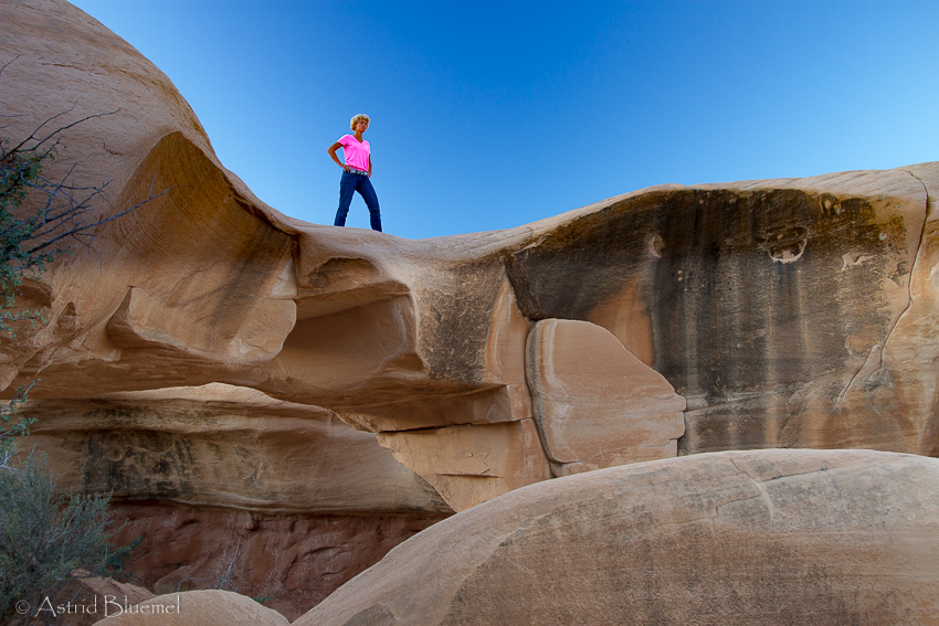
Tina posing at Devils Playground
At 16:00 we leave for Devils Playground, which took us about an hour to drive. The turn off from Hwy 12 can easily be missed, it is an inconspicuous little dirt road on the left between mile 62 and 63, about 2 miles east of Escalante. The road gets bumpier and bumpier and Christian is known for his speedy driving, he got us there fast, but had we had any third teeth …they would have spontaneously jumped out of our mouths during this drive, boy it was bumpy and rough ! The Devils Playground is another beautiful spot, lots of white and beige coloured rock formations, a few arches and many photogene spots. We spread out but at sunset all meet near the one pretty arch and somehow all fit in the rather tight spot which gets us the best angle, Christian and me on the ledge, Frank under the tree and Tina, Anastasia and Jürg in the gap. After dark we light the arch with our headlights for some special effects. From there we have to hurry back because most restaurants close at 21:00 and by the time we leave it is already 20:15. We make it to Escalante in time and have good pizza at the Escalante Outfitters, we share one big one, it is immense so we barely manage to eat it all. I fall asleep on the drive back home. But once there we have to do some night photography again, simply because it is so nice and dark here, there are thousands of stars shining just for us. We get to bed somewhere around midnight. Must sleep now.
Day 11: Thu 8.10.15 : Boulder to Bryce Canyon
The next morning no sunrise shoot so we can sleep late one more time. Today the alarm goes at 07:00 but only because we have to download photos, we were too tired yesterday. No extra breakfast today, turns out yesterday was a mistake and was ment only for the French tour group. So we order blueberry pancakes which are very good too, glad we ordered one portion for the two of us ! Generally portions are big enough for two, where ever you go, whatever you eat.
We leave at 09:00 in direction Bryce Canyon. No good coffee places so we keep driving, pass Escalante town once more, untill we get to Henrieville where we turn off to go to the Kodachrome National Monument. Once again very scenic and lots of red rocks, we do the Chimney Rock, which is just one big white pillar out in the open. There is a sign there explaining they took Kodachrome photos here of this rock and they turned out so good they named the park after it. A loop walk wasn’t too spectacular either so we went through this park rather fast and went back to our main highway. Continue on to Bryce on the scenic byway Hwy 12. For lunch we already are at our destination, Ruby’s Inn, Best Western, close to the entrance of the National Park. The food is okay considering this is a gigantic motel and they cook for hundreds of people. Since the rooms are not ready we do a short drive to Red Rock Canyon, and walk a loop there. Nothing much. So we slowly return, get the rooms, have 30 min to spare and at 16:30 at last we go in to the park.
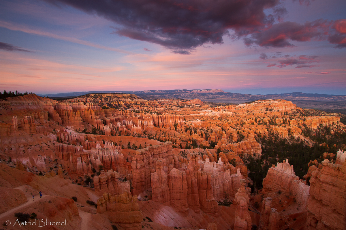
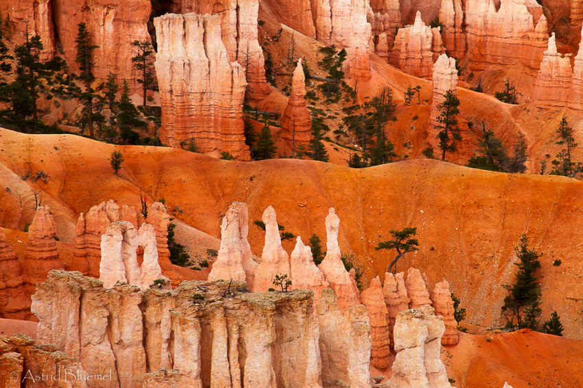
Bryce Canyon
First stop at Inspiration Point. It truly is inspiring, hundreds of towers, peaks and ridges in orange and white dotted with some dark green trees, this is once again an amazing canyon ! After 45 min we continue on to sunset point, this is the place to be, great views in any direction. We stay till the last light has gone before we head back to Ruby’s for dinner. Regula jumps out and stands in line to get a table whilst we park the van. Just in time ! As we come in there is a queue of about 40 people ! Dinner is okay and after that we have some spare time to download etc.
DAY 12 : Fri. 9.10.15 : Bryce Canyon to Las Vegas
Our last sunrise shoot. At 06:45 we all hopped in the bus to go to sunset point once again. This really is the best spot for sunrise. We are all dressed up like in winter, it is only 3 C, we do need the gloves and multiple layers of clothing ! We spread out, everybody has a different favourite spot. As soon as the sun comes out the red and especially the whites really glow. When the sun is out we hike down between the rock formations on the Navajo Trail ( 1,3 miles ). Do go clockwise, it is steeper down but therefore a little better going up, but I tell you it’s far up, damned steep, and we are glad it is early morning and not so warm yet. We are puffing and panting and have to put in several “photo stops” to catch our breath. We worked hard for our breakfast today !

Bryce Canyon Thor’s Hammer at sunrise
At 11:00 we leave for Las Vegas, lots of driving and the scenery is not very interesting so everyone, at some point, doses off, we all need some extra sleep after all the long hours of photographing. Lunch a little after 13:00 in a small town on the Interstate called St. George. The panini in Cafe Alure, are okay. On to Starbucks for a good coffee after a few days of being deprived of anything resembling coffee or containing coffeine. Yoh, thank god for the instant coffee from Starbucks we bought at Moab which helped us survive till here. The Starbucks is on the other side of the Interstate, and it just happened to have lots of shops and outlets there, and we had an hour to spare….. So the ladies gulped down their coffees and hit the shops, I got a matching pair of earrings to my Indian bracelet ! And it was a bargain, end of season sale, so I got 20% off !
At 15:00 we got on the Interstate south again, 85 more miles to the Valley of Fire. The scenery is more interesting now, the road winds through mountains, a gorge with steep cliff faces on both sides. They are so high and steep you can only see the top if you press your nose to the window. Once out of there the land is flat and empty, back to boring again, we’ll sleep a little more till we get to the Valley of Fire. By the way we are in Arizona now, put the clock back by 1 hr.

Just about an hour later we leave the Interstate 15 at Overton and continue on the Hwy 169 south, more red rocks around now. We enter the park, put the fee of 2$ per person in the envelope, and from the parking lot hike the very short trail to the Elephant Rock. Well, with a lot of imagination you can see an elephant in this rock, one sitting on its bum and supporting himself on his trunk. Frank even climbs up and sits on its “neck”, we’re all glad when he gets down safely. We drive on and as we stop at the next parking lot a lady comes and tells us to move, she is expecting a wedding party in a stretch limousine. Bad luck for her, we’ve spotted two mountain goat right on top of the first rock formation here. We stay and get another bonus, they at first move out of sight, then show up on the other side and come down, not just two but six ! We get some cool shots. That’s really hard at the moment because it is once again not so cool anymore, on the contrary it’s very, very hot. In Bryce at 2400m it was cool in the mornings and comfortable the rest of the day. Here at 300m it is, at 4 in the afternoon, still well over 30C.
Trying to get a good spot
We move on and at parking lot nr.3 we start our hike to the Fire Wave Rock which is only about 10-15 min. Unfortunately there are some Chinese photographers at the spot, our “least favourite tourist brand”. As expected they are totally selfish, ignorant, unsocial and constantly tell us to move by giving hand signals and shouting something in Chinese. Plus they pick the best spot and stay forever even though there are about 15 people waiting. They themselves of course stand in the way all the time, walk into our pictures and act as if they own the place. Yvonne tells some Chinese guy : hey Pinky move over ! Of course he doesn’t understand, but we all roar with laughter. At one point Christian asks if one of them speaks English, only one does, and he tells him to translate to the others to give us some time and free space or we will start posing for our group photo exactly in best light in the middle of the Fire Wave. That helps and we finally get to the good angle. Honest, you have to fight for every inch of space on this rock ! As Tina moves up to the top to pose as our model they are delighted too. Boy, if they ever publish a photo with her we will sue them ! In the end everybody is happy, and we get a gorgeous sunset and beautifully coloured sky in just about every direction around us. A worthy last shoot !

Our supermodel Tina poses for us one last time
From there a hike in the dark back to the car and a 1 hr drive to Vegas. It is incredible, as we get closer and come down the hills Las Vegas spreads out in front of us. As far as you can see there are lights on the horizon, this city is so big and so very, very well lit. We have very good pasta at Romans Macaroni Grill right beside the Interstate then the last short drive to our motel the La Quinta Inn & Suites, very close to the airport, with free shuttle to the airport and shopping malls and the strip. We say goodbye to Tina who is sleeping late tomorrow and is staying on in Vegas for two more nights. After that we’re off to bed, but only after our final packing is done.
DAY 13 : Sat 10.10.15 : going home
We have breakfast at 08:00 and leave the hotel at 08:45 for the Vegas South outlets with Regula and Christian and Frank. Yvonne and Anasztazia come along too but intend to stay longer, we leave there at 10:15 so we reach the airport in time. Three hours before the flight, much too early and we now sit and wait for two hours, boring ! In Denver we only have one hour, but our plane is early and we easily make it. There is even spare time for an ice cream. And now we fly to Frankfurt and from there to Zürich, hope to get home around 16:00 tomorrow.
Compliments go to our hosts Christian and Regula, they are really nice.
Regula has everything under control from bookings, checking in to taking i-phone pics that can compete with ours. She has an app for everything, sunrise and sunset times, weather, restaurants, Starbucks locations, spot where the sun rises and its movement across the sky and more. Best of all she keeps us safe: when we stand in the middle of roads or at deep drops, and in our enthusiasm, tend to forget the dangers.
Christian is a little crazy, but a good creative person has to be. He is even worse than Jürg and climbs on every hill, rock, ledge, barricade he can. Runs, hops and is always first to be there. Takes great photos and has an extremely experienced eye for fotogenic situations and locations. If we think we are at a good spot, he comes and does it better. He’s a fun person to be with !
Copyright 2015 photo by Astrid & Jürg Blümel, text by Astrid Blümel for bluemelphoto.ch